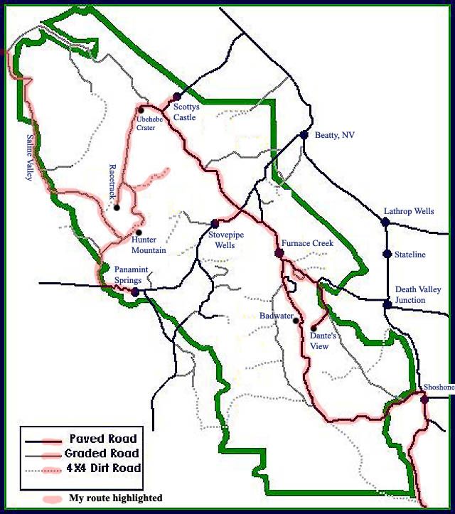
Here's a map of Death Valley National Park with my route highlighted. I came in from the southeast, from Baker, CA, on I-15. From Shoshone, I took Route 178 into the park and stopped at Badwater, 280 feet below sea-level. I then continued up 178 to Furnace Creek, the main visitors' center, where I camped the first night. The next morning I headed down Route 190, to Dante's View, then back to Furnace creek, stopping to take the loop through Twenty Mule Team Canyon on the way. From Furnace Creek I went up to Stovepipe Wells, another visitors' center, and then to Scottys Castle. After stopping at Scottys Castle, I was off to Ubehebe Crater, a volcanic crater, then The Racetrack, a dry lake. After bactracking some from The Racetrack, I headed for Hunter Mountain, with a couple side trips along the way. I camped at the top of the pass on Hunter Mountain, and was off to Panamint Springs for gas the next morning. Then it was back towards Hunter Mountain, but this time I turned north and left the park through Saline Valley, a remote area, similar to Death Valley, where I went 80 miles in 4 hours, without seeing another person. From the end of the highlighting I headed west into Big Pine, CA, on US Route 395. The scenery on the trip was incredible, and in June there were very few people around, especially off the main, paved highways. Distances by road: 18 miles from Badwater to Furnace Creek, 24 miles from Furnace Creek to Stovepipe Wells, 42 miles from Stovepipe Wells to Scottys Castle, 37 miles from Ubehebe Crater to Hunter Mountain, and 90 miles from Panamint Springs through, Saline Valley, to the junction with Big Pine Road (at the edge of map, where highlighting ends).
Death Valley Page
Return to Home
Page created 22 Septempber 2002, Last updated 22 September 2002 17:28 Pacific Daylight Time